South Federal Way
The South Federal Way Segment extends from South 344th St through Federal Way, the Puyallup Tribe of Indians Reservation, Milton, and unincorporated Pierce County to the City of Fife boundary near Wapato Way East.
The following station area information focuses on the South Federal Way
Preferred Alternative
. Sound Transit continues to study multiple alternatives in the Final Environmental Impact Statement (EIS).
South Federal Way Station design
The Preferred South Federal Way Station would be east of SR 99 between South 352nd St and South 356th St. Sound Transit and the City of Federal Way are collaborating to design a station that will support the needs of the Federal Way community. Our station plans propose several improvements to the area directly within and around the station including:
- Sidewalks and bike lanes to ensure people of all ages and abilities can walk, bike, or roll within the station area.
- Parking, including a surface parking lot and additional street parking on some streets within the station area.
- Landscaping and trees lining all streets adjacent to the station, providing shade and separation from vehicles for people walking, biking, and rolling.
Explore the early concepts for the Preferred South Federal Way Station
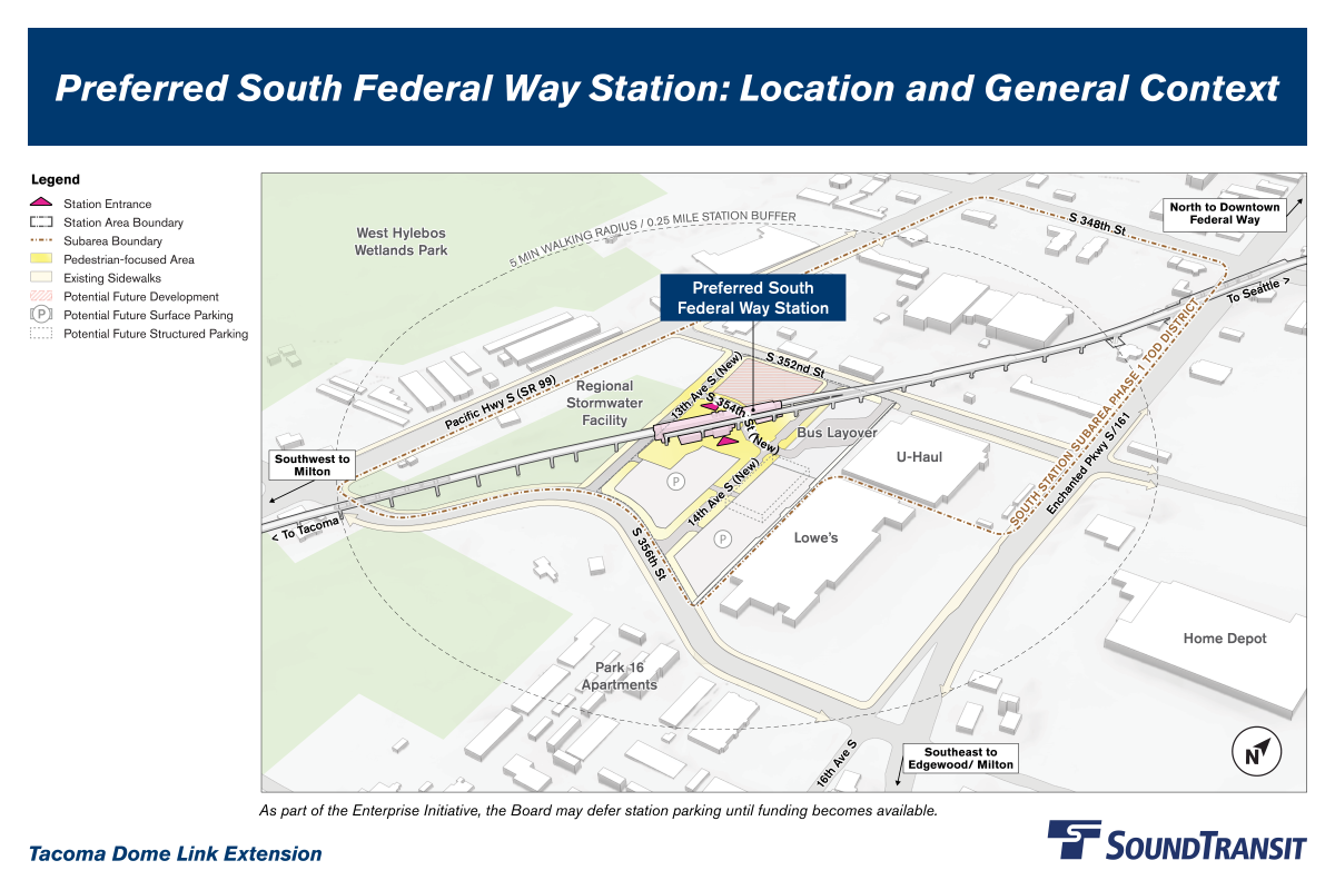
The Preferred South Federal Way Station in the context of surrounding areas, including the West Hylebos Wetlands Park to the west and businesses surrounding the rest of the station site.
The Preferred South Federal Way Station in the context of surrounding areas, including the West Hylebos Wetlands Park to the west and businesses surrounding the rest of the station site.
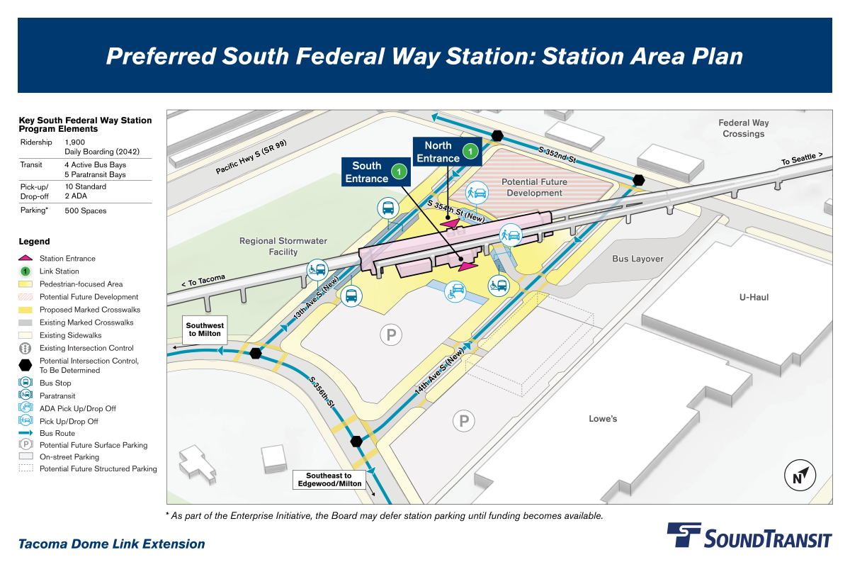
A closer view of the station, highlighting entrances and key station features like plaza areas, bus and paratransit stops, sidewalks, pick-up and drop-off zones, and parking.
A closer view of the station, highlighting entrances and key station features like plaza areas, bus and paratransit stops, sidewalks, pick-up and drop-off zones, and parking.
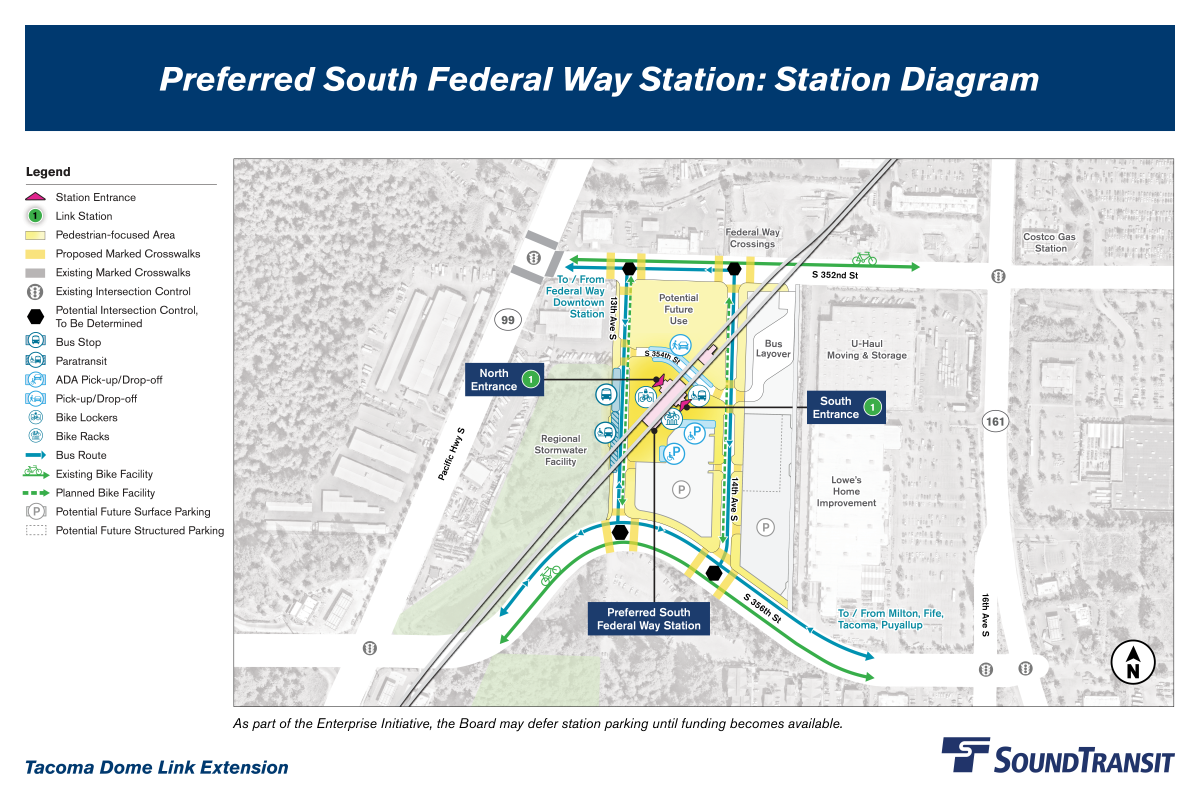
Diagram of the station and travel routes for people walking, biking, rolling, driving, or taking transit.
Diagram of the station and travel routes for people walking, biking, rolling, driving, or taking transit.
Station access planning
Sound Transit and the City of Federal Way are identifying improvements that will make it easier to travel to the Preferred South Federal Way Station while walking, biking, or rolling. The potential projects below are informed by the City of Federal Way’s development plans and previous feedback from the City and the public. Please note that funding is limited, meaning there may not be the resources to build all potential station access projects below.
As you review these potential projects, consider whether they would make it easier to get to the station. Your feedback will help inform which projects are built and how they’re designed.
Learn about the potential South Federal Way station access projects
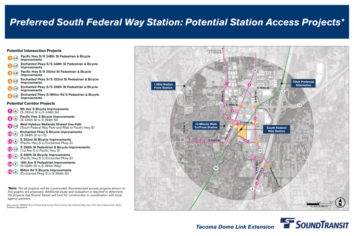 Aerial map of the future Preferred South Federal Way Station showing 15 proposed station access projects within a one-mile, or approximately 10-minute walk, of the station. The text below includes all project names, locations, and descriptions.
Map outlining all potential station access projects for the Preferred South Federal Way Station. See details about each project in the text below.
Potential intersection projects
- Pacific Hwy S/S 348th St Pedestrian & Bicycle Improvements:
Intersection improvements
at Pacific Hwy South and South 348th St.
- Enchanted Pkwy S/S 348th St Pedestrian & Bicycle Improvements: Intersection improvements at Enchanted Pkwy South and South 348th St.
- Pacific Hwy S/S 352nd St Pedestrian & Bicycle Improvements: Intersection improvements at Pacific Hwy South and South 352nd St.
- Enchanted Pkwy S/S 352nd St Pedestrian & Bicycle Improvements: Intersection improvements at Enchanted Pkwy South and South 352nd St.
- Enchanted Pkwy S/S 356th St Pedestrian & Bicycle Improvements: Intersection improvements at Enchanted Pkwy South and South 356th St.
- Enchanted Pkwy S/Milton Rd S Pedestrian & Bicycle Improvements: Intersection improvements at Enchanted Pkwy South and Milton Rd South.
Potential corridor projects
- 9th Ave S Bicycle Improvements: Bicycle improvements on 9th Ave South from South 332nd St to South 348th St.
- Pacific Hwy S Bicycle Improvements: Bicycle improvements on Pacific Hwy South from South 336th St to South 359th St.
- West Hylebos Wetlands Shared-Use Path:
Shared-use paths
along the northeastern edge of West Hylebos Wetlands Park from South Federal Way Park-and-Ride to Pacific Hwy South.
- Enchanted Pkwy S Bicycle Improvements: Bicycle improvements on Enchanted Pkwy South from South 348th St to I-5.
- S 352nd St Bicycle Improvements: Bicycle improvements on South 352nd St from Pacific Hwy South to Enchanted Pkwy South.
- S 356th St Pedestrian & Bicycle Improvements: New sidewalks and bicycle lanes on South 356th St from 1st Ave South to Pacific Hwy South.
- S 356th St Bicycle Improvements: Bicycle improvements on South 356th St from Pacific Hwy South to Enchanted Pkwy South.
- 16th Ave S Pedestrian Improvements: Sidewalk improvements on the east side of 16th Ave South from South 359th St to South 364th Way.
- Milton Rd S Bicycle Improvements: Bicycle improvements on Milton Rd South from Enchanted Pkwy South to South 369th St.