Final EIS alternatives
Sound Transit expects to publish the Final Environmental Impact Statement (EIS) in 2027. Station planning focuses on the Preferred Alternative, but the Final EIS will study all route and station alternatives that were evaluated in the Draft EIS. Sound Transit also studies a “No-Build” Alternative in the EIS. The “No-Build” Alternative considers how the transportation system would operate if TDLE was not built and provides a baseline for measuring the impacts of the other alternatives.
The Federal Way (FW) Segment extends from the Federal Way Downtown Station to approximately South 344th Street.
On June 27, 2024, the Sound Transit Board selected the South 336th Street site as the project to be built for the Operations and Maintenance Facility (OMF) South along with the 1.4-mile segment of light rail tracks connecting it to the Federal Way Downtown Station. Based on the Sound Transit Board’s action, we will construct the FW Segment of tracks as part of the OMF South project.
OMF South will support daily light rail function once TDLE is in service. That is why the TDLE Draft EIS studied impacts of operating the facility.
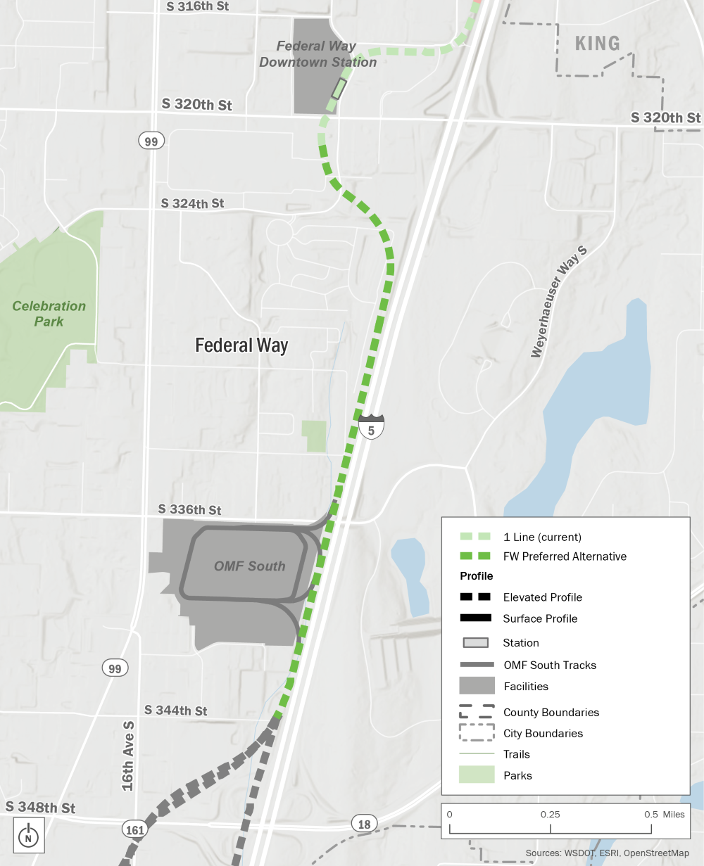 Map outlining the where the current Link 1 line ends in Downtown Federal Way and the Federal Way Preferred Alternative begins. The segment is planned mostly along Interstate 5 from South 320th Street to South 344th Street. The future OMF South is shown south of South 336th Street.
Federal Way Segment overview map showing the FW Preferred Alternative.
Sound Transit continues to study all route and station alternatives in the South Federal Way Segment. Please note, we updated the names of some alternatives.
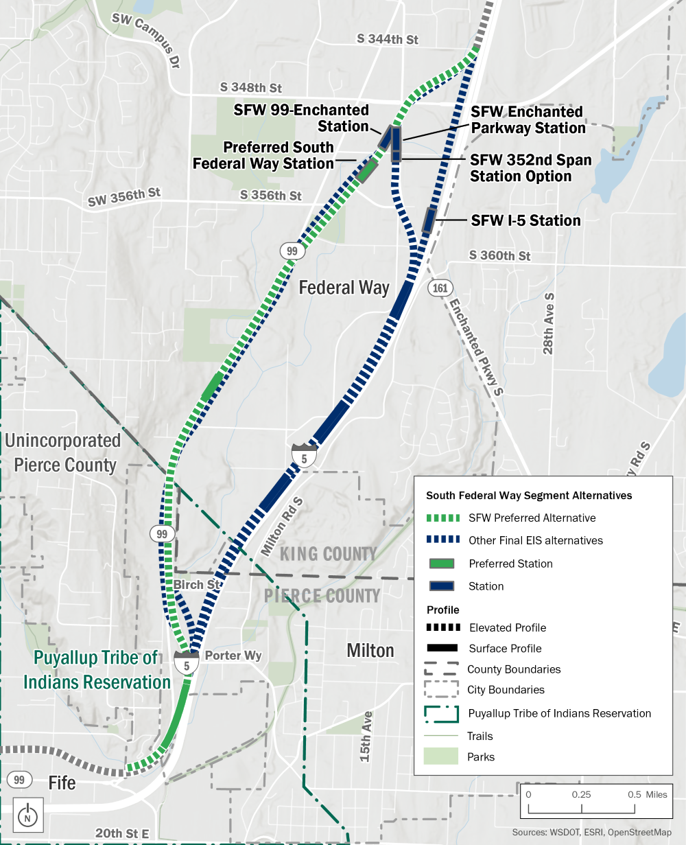 Map outlining the South Federal Way segment from approximately South 344th Street to South 320th Street. The map shows the Preferred Alternative and Station running along State Route 99. There are three other route alternatives shown, running along State Route 99 or Interstate 5, as well as three other station alternatives and one station option.
South Federal Way Segment overview map showing the SFW Preferred Alternative and other Final EIS alternatives.
South Federal Way alternatives
In the South Federal Way Segment, we’re studying four alternatives and two design options:
- SFW Preferred Alternative (formerly SF 99-West)
- SFW Enchanted Parkway Alternative
- SFW I-5 Alternative
- SFW 99-East Alternative
- Porter Way Design Option
The Porter Way Design Option could be paired with the SFW Preferred Alternative or the SFW 99-East Alternative.
South Federal Way stations
We’re studying four station locations and one station option in South Federal Way that each pair with one respective alternative:
- Preferred South Federal Way Station
- SFW Enchanted Parkway Station
- SFW 352nd Span Station Option
- SFW I-5 Station
- SFW 99-Enchanted Station
Sound Transit continues to study all route and station alternatives in the Fife Segment. The following route and station alternatives include a new design option in addition to the Draft EIS alternatives. Please note, we updated the names of some alternatives.
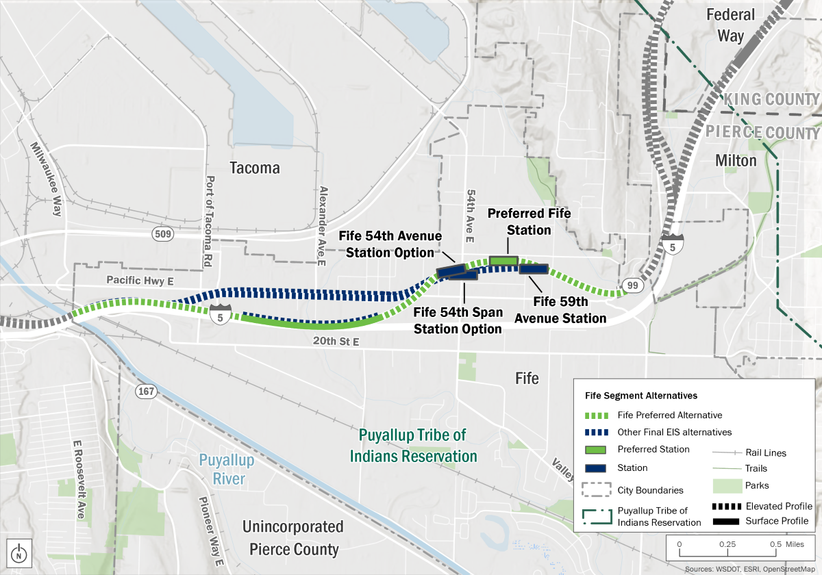 Overview map of the Fife Segment from approximately the Wapato Way East connection to Pacific Highway East and the 20th Street East crossing under Interstate 5. The map shows the Fife Preferred Alternative and Station. There are two other route alternatives, one design option, one other station location, and two station design options shown.
Fife Segment overview map showing the Fife Preferred Alternative and other Final EIS alternatives.
Fife alternatives
In the Fife Segment, we’re studying three alternatives:
- Fife Preferred Alternative (formerly Fife I-5)
- Fife Pacific Highway
- Fife Median
The Preferred Fife Alternative only pairs with the Preferred Fife Station. The two other alternatives can be paired with any station in the Fife Segment.
*The Elevated Design Option would be a modification to the Preferred Alternative, elevating the guideway along I-5 from retained fill to elevated structure between about 46th Avenue E and east of 34th Avenue E.
Fife stations
We’re studying four station locations in Fife:
- Preferred Fife Station
- Fife 59th Avenue Station (formerly the Preferred Station)
- Fife 54th Avenue Station Option
- Fife 54th Span Station Option
The Tacoma Segment includes the area from the Fife/Tacoma city limit across the Puyallup River to the existing Tacoma Dome Station, through reservation and trust lands of the Puyallup Tribe of Indians. The Tacoma Segment of the project will have two stations: Portland Avenue and Tacoma Dome. Please note, we updated the names of some alternatives.
 Overview map of the Tacoma Segment which extends from the start of the Puyallup River along Interstate 5 and ends near East D Street on either East 25th or 26th Street. The map shows the Tacoma Preferred Alternative, the Preferred Portland Avenue Station, and the Preferred Tacoma Dome Station. In the Portland Avenue station area, there is one other design option and station option shown. In the Tacoma Dome station area, there are three other alternatives and station locations shown, as well as one design option.
Tacoma Segment overview map showing the Tacoma Preferred Alternative and other Final EIS alternatives.
Portland Avenue stations
After crossing the Puyallup River, all alternatives would travel northwest to serve the elevated Portland Avenue Station located between East Portland Avenue and East Bay Street.
We’re studying two station locations near Portland Avenue that could be paired with any of the alternatives:
- Preferred Portland Avenue Station
- Portland Avenue Span Station Option
Tacoma alternatives
In the Tacoma Segment, we’re studying four alternatives:
- Tacoma Preferred Alternative (formerly Tacoma Close to Sounder)
- Tail Tracks Design Option
- Tacoma 25th Street-West Alternative (formerly Preferred Tacoma 25th Street-West)
- Tacoma 25th Street-East Alternative
- Tacoma 26th Street Alternative
Each alternative could be paired with either of the Portland Avenue stations.
Tacoma Dome stations
We’re studying four Tacoma Dome Station locations that each pair with one respective alternative:
- Preferred Tacoma Dome Station (formerly Close to Sounder)
- Tacoma 25th Street-West Station
- Tacoma 25th Street-East Station
- Tacoma 26th Street Station
All of the alternatives would cross the Puyallup River north of I-5. Two bridge types are being studied for the crossing:
- A long-span bridge that would completely span the river.
- A pier-supported bridge that would have piers in the river.
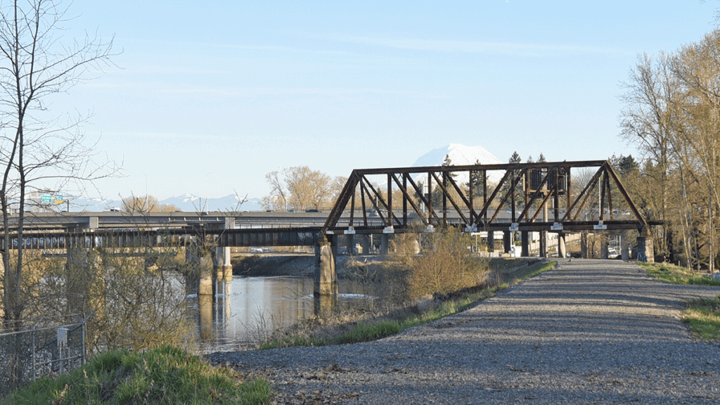
Existing view of the I-5 bridge deck
Long-span bridge visual simulation
The long-span bridge (segmental box girder) would be approximately 35 feet higher than the nearby I-5 bridge deck. The long-span bridge would be taller than the pier-supported bridge and could obstruct views of Mount Rainier, depending on the type of long-span bridge.
The long-span bridge would have fewer long-term impacts on aquatic habitats due to the lack of in-water structures.
Pier-supported bridge visual simulation
The pier-supported bridge would be about 10 feet higher than the I-5 bridge deck and more aligned with the Washington State Department of Transportation (WSDOT) I-5 bridge, making the structure less prominent.
The pier-supported bridge would affect the flow of water, sediment, and other natural resources. Construction of the in-water piers may adversely affect fish and marine mammals, including endangered species.
What’s an EIS?
An EIS helps Tribal Nations, agencies, and the public understand a project’s potential effect on the natural and built environments. It also identifies ways to mitigate any unavoidable impacts. Through this process, we analyze how all alternatives affect the environment and identify potential mitigation measures. The EIS helps decision-makers, the public, and our project partners consider the possible environmental impacts of each potential site during construction and operation.
What do we study in the EIS?
- Acquisitions, displacements, and relocations.
- Air quality.
- Economics, including impacts to businesses.
- Ecosystems.
- Electromagnetic fields.
- Energy.
- Environmental justice.
- Geology and soils.
- Hazardous materials.
- Historic and archaeological resources.
- Land use.
- Noise and vibration.
- Parks and recreational resources.
- Public services, safety, and security.
- Social impacts, community facilities, and neighborhoods.
- Transportation (traffic, freight, navigation, transit, non-motorized).
- Utilities.
- Visual and aesthetics.
- Water resources.
 To learn more about the different types of fieldwork activities we may conduct in your neighborhood, check out our fact sheet .