Español |
ខ្មែរ |
한국어 |
Русский |
Tiếng Việt
Welcome
Sound Transit Board identifies Preferred Alternative
At its June 26 meeting, the Sound Transit Board of Directors identified a preferred alternative for the Tacoma Dome Link Extension (TDLE). The Preferred Alternative includes:
- South Federal Way (SF) Segment: SF 99-West alignment with a design refinement to transition the alignment to the east side of SR 99 near the King/Pierce County line and the SF 99-352nd Station.
- Fife Segment: Fife I-5 alignment with the Fife Station.
- Tacoma Segment: Close to Sounder alignment with the Portland Avenue Station and Close to Sounder Station.
Prior to identifying the Preferred Alternative, the Board considered the findings from the Draft Environmental Impact Statement (EIS), public comments received on the Draft EIS, additional analysis in response to Draft EIS public comments, Sound Transit’s Equitable Engagement Tool, and staff recommendations. Read more about the Board action in our press release and the Board Motion, or watch the recording.
The identification of a preferred alternative is not a final decision on the project to be built. This action indicates where the Board is leaning based on the information available at this time. The Board will make a final decision on the project to be built after the evaluation of the Preferred Alternative and other alternatives in the Final EIS, expected in 2027.
Next steps
Sound Transit continues to advance project design and fieldwork in preparation for the Final EIS. We’ll continue to work with Tribal Nations, local jurisdictions, property owners, and community members throughout the project corridor.
Stay tuned for details on upcoming station area planning workshops, and encourage your friends, family, and neighbors to subscribe to project updates to stay informed.
Need more information now?
Review the project overview or visit our website for additional background information and resources. Sign up for email updates for all the latest news as the Tacoma Dome Link Extension develops.
Have questions or want to schedule a briefing with a member of the project team?
Contact us
Email: tdlink@soundtransit.org
Phone: 206-398-5453
Project overview
The Tacoma Dome Link Extension includes four segments: Federal Way, South Federal Way, Fife, and Tacoma. The project is in the planning phase.
Expanding regional light rail from Federal Way to Tacoma
The TDLE will add nearly 10 miles of light rail service to our regional transit system via mostly elevated tracks as it crosses through the cities of Federal Way, Milton, Fife, and parts of King and Pierce Counties. It also crosses the ancestral and reservation lands of the Puyallup Tribe of Indians. This project includes four new light rail stations in the South Federal Way, Fife, Portland Avenue, and Tacoma Dome areas. These stations will also connect to transit services, including the Sounder S Line, the T Line, ST Express, King County Metro, Pierce Transit, and Amtrak.
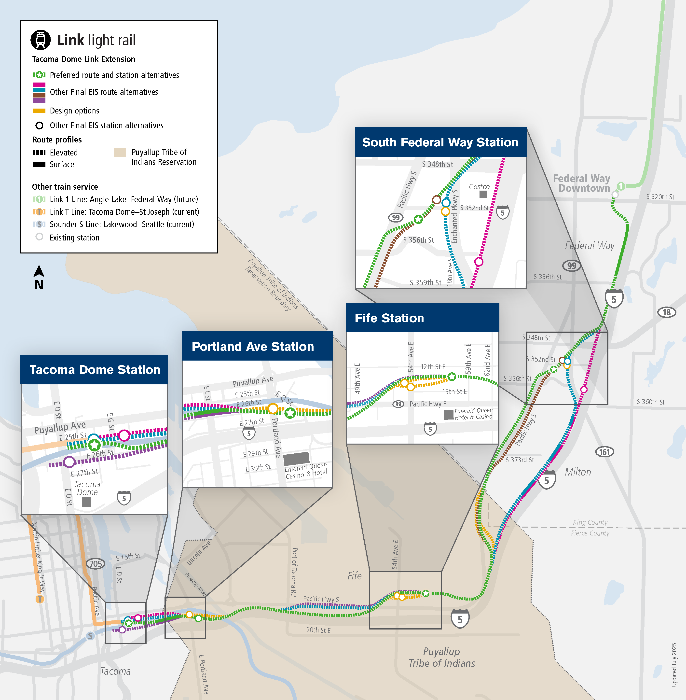
The text below describes the image above
Map showing the Tacoma Dome Link Extension project. The project starts at the Federal Way Transit Center with a route traveling south with a station area in South Federal Way in the vicinity of Federal Way Crossings shopping center. The route continues south and curves west to enter a station area in Fife. The route continues west to cross over the Puyallup River to enter two station areas, one near Portland Avenue and one near the Tacoma Dome, where the project ends.
2016 Approval of ST3 projects
2017-2027 Planning
- Alternatives development
- ST Board identifies alternatives to study in an EIS, including a preferred alternative in some locations
- Draft Environmental Impact Statement
- ST Board confirms or modifies the preferred alternative
- Final Environmental Impact Statement
- ST Board selects project to be built
- Federal Transit Administration issues Record of Decision
2027-2029 Design
- Final route
design
- Final station designs
- Procure and commission station and public art
- Obtain land use and construction permits
- Property acquisition/relocation
2029-2035 Construction
- Groundbreaking
- Construction updates and mitigation
- Safety education
- Testing and pre-operations
2035 Forecasted In-Service Date*
These dates are subject to change.
* Parking at the South Federal Way and Fife stations is forecasted to open in 2038.
Draft EIS
We published the Draft EIS on Dec. 13, 2024, and invited Tribal Nations, agencies, and the public to provide formal comments during a 60-day comment period that ended on Feb. 10, 2025. Read the Draft EIS Engagement Summary and the Draft EIS Comment Summary Report for more information.
After considering the Draft EIS findings, comments received, and the project staff recommendation, the Sound Transit Board identified the Preferred Alternative click for definition. Sound Transit will now prepare a Final EIS that analyzes the Preferred Alternative along with the other alternatives evaluated in the Draft EIS.
How to access the Draft EIS
The Draft EIS includes analysis of the alternatives studied during environmental review. Learn how each alternative could affect historic and cultural resources, homes and businesses, ecosystem resources, and more.
- Access the Draft EIS online: soundtransit.org/tdlink-documents
- Read the Draft EIS Executive Summary. You can also review the full document and supporting appendices for more detail.
- Explore the Draft EIS Alternatives Guide.
- See the Station Area Planning Report.
What’s an EIS?
An Environmental Impact Statement helps Tribal Nations, agencies, and the public understand a project's potential impacts on the natural and built environments. It also identifies ways to mitigate any unavoidable impacts. Through this process, we analyze how each alternative affects the environment and identify potential mitigation measures. The EIS helps decision-makers, the public, and our project partners consider the possible environmental impacts of each potential site during construction and operation.
- Acquisitions, displacements, and relocations
- Air quality
- Economics, including impacts to businesses
- Ecosystems
- Electromagnetic fields
- Energy
- Environmental justice
- Geology and soils
- Hazardous materials
- Historic and archaeological resources
- Land use
- Noise and vibration
- Parks and recreational resources
- Public services, safety, and security
- Social impacts, community facilities, and neighborhoods
- Transportation (traffic, freight, navigation, transit, non-motorized)
- Utilities
- Visual and aesthetics
- Water resources
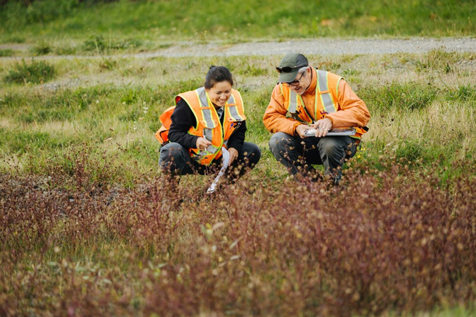
To learn more about the different types of fieldwork activities we may conduct in your neighborhood, check out our fact sheet .
Fact Sheet and Executive Summary
Provides a project introduction, a shortened version of the Draft EIS findings, and next steps for the project.
Chapter 1: Purpose and Need for Tacoma Dome Link Extension
States what problems the project will address and why the investment in this transit project is needed. This section also includes the project timeline.
Chapter 2: Alternatives Considered
Describes the alternatives evaluated in the Draft EIS, including alignment and station locations. This section includes how the alternatives were developed, how they will be constructed, how long construction will take, information about the stations, and estimated opinion of probable cost. Additional information about other alternatives considered in earlier phases of the project can be found in Appendix I.
Chapter 3: Transportation Environment and Consequences
Presents analysis of the existing transportation system in the project area and discusses potential impacts of the alternatives to regional facilities, transit operations, traffic, freight mobility, nonmotorized access, safety, parking, and navigation. This section discusses ridership and travel times for each alternative and pedestrian and bicyclist access at each station area.
Chapter 4: Affected Environment and Environmental Consequences
Discusses the affected environment and environmental consequences of the project related to the following resources: acquisitions/displacements/relocations, land use, economics, social resources/community facilities/neighborhoods, visual/aesthetics, air quality/greenhouse gas emissions, noise/vibration, water resources, ecosystems, energy impacts, geology/soils, hazardous materials, electromagnetic fields, public services/safety/security, utilities, historic and archaeological resources, parks and recreational resources, and Section 4(f) resources.
Chapter 5: Cumulative Impacts
Describes the project’s effects combined with past, present and future effects of other projects. The cumulative impact assessment identifies potential consequences that might not be apparent when the project is considered in isolation.
Appendices
- Appendix A: Draft EIS Support Information
- Appendix B: Public Involvement and Tribal and Agency Coordination
- Appendix C: Environmental Justice
- Appendix D: Draft Individual Section 4(f) Evaluation
- Appendix E: Not in use
- Appendix F: Conceptual Design Drawings
- Appendix G: Present and Reasonably Foreseeable Actions
- Appendix H: Supporting Information for Other Technical Analysis
- H1 Potentially Affected Parcels
- H2 Land Use
- H3 Economics Supporting Information
- H4 Air Quality Supporting Information
- H5 Water Resources Supporting Information
- H6 Geology and Soils Background Information
- H7 Hazardous Materials Supporting Information
- 09b - Appendix H7 Attachment A Phase I ESA 3244 3245 3246 3247
- 09c - Appendix H7 Attachment B Phase I ESA 3947 3933
- 09d - Appendix H7 Attachment C Phase I ESA 4030
- 09e - Appendix H7 Attachment D Phase I ESA 4047
- 09f - Appendix H7 Attachment E Phase I ESA 4435 4443
- 09g - Appendix H7 Attachment F Phase I ESA 4437
- 09h - Appendix H7 Attachment G Phase I ESA 4461 4476 4506 1 / 2429 59
- H8 Utilities Supporting Materials
- Appendix I: Alternatives Development Supporting Documents
- Appendix J: Technical Reports
- J1 Transportation Technical Report
- J2 Visual and Aesthetics Resources Background and Simulation Analysis
- J3 Noise and Vibration Technical Report
- J4 Ecosystems Resources Technical Reportul
- 14a - Appendix J4 - Ecosystem Resources Technical Report
- 14b - Appendix J4 Ecosystem Resources Technical Report
- 14c - Appendix J4 - Ecosystem Resources Technical Report
- 14d - Appendix J4 - Ecosystem Resources Technical Report
- 14e - Appendix J4 - Ecosystem Resources Technical Report
- 14f - Appendix J4 Ecosystem Resources Technical Report Attachments
- 14g - Appendix J4 Ecosystem Resources Technical Report Attachments
- 14h - Appendix J4 Ecosystem Resources Technical Report Attachments
- 14i - Appendix J4 Ecosystem Resources Technical Report Attachments
- 14j - Appendix J4 Ecosystem Resources Technical Report Attachments
- J5 Historic and Archaeological Resources Technical Report
- 15a - Appendix J5 - Historic and Archaeological Resources Technical Report (Redacted)
- 15b - Appendix J5 - Historic and Archaeological Resources Technical Report (Redacted)
- 15c - Attachment J5.1, J5.2, J5.3, J5.4
- 15d - Attachment J5.5
- 15e - Attachment J5.5
- 15f - Appendix J5 Attachments J5.6 to J5.11
- 15g - Appendix J5 Attachment J5.12 and J5.13
Federal Way
Federal Way
The Federal Way (FW) Segment extends from the Federal Way Downtown Station to approximately South 344th Street.
On June 27, 2024, the Sound Transit Board selected the South 336th Street site (preferred alternative click for definition) as the project to be built for the Operations and Maintenance Facility (OMF) South along with the 1.4-mile segment of light rail tracks connecting it to the Federal Way Downtown Station. Based on the Sound Transit Board's action, we will construct the FW Segment of tracks as part of the OMF South project. Due to the timing of the Board action on OMF South, the TDLE Draft EIS includes impacts for constructing the FW Segment. The TDLE Draft EIS also analyzes the operational effects of this track section as it will support daily light rail function once TDLE is in service.

Click to enlarge
South Federal Way
Learn about the alternatives and stations studied in the South Federal Way segment.
The South Federal Way Segment extends from South 344th Street through Federal Way, the Puyallup Tribe of Indians Reservation, Milton, and unincorporated Pierce County to the City of Fife boundary near Wapato Way East.
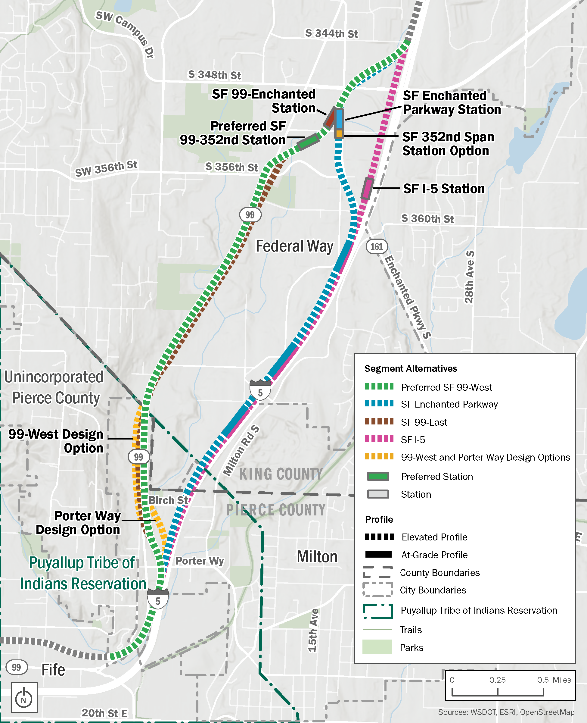
South Federal Way alternatives
In the South Federal Way Segment, there are four alternatives and two design options:
- Preferred SF 99-West Alternative*
- SF Enchanted Parkway Alternative
- SF I-5 Alternative
- SF 99-East Alternative
- 99-West Design Option
- Porter Way Design Option
*The Preferred SF 99-West Alternative differs from the SF 99-West Alternative in the Draft EIS. During the Draft EIS comment period, we received concerns about the number of property impacts, potential relocations, and wetland impacts associated with the SF 99-West Alternative through Milton. To potentially reduce impacts in this area, Sound Transit began studying a modification to this alignment that transitions from the west side to the east side of SR 99 at the King/Pierce County line and continues through Milton before aligning with the west side of I-5 near Fife. The Preferred Alternative includes this refinement. The former path of the SF 99-West Alternative through this section is now called the 99-West Design Option.
South Federal Way stations
We studied four station locations and one station option click for definition in South Federal Way:
- Preferred SF 99-352nd Station
- SF Enchanted Parkway Station (352nd Span Station Option)
- SF I-5 Station
- SF 99-Enchanted Station
Fife
Learn about the alternatives and stations studied in the Fife segment.
The Fife Segment is within the reservation and trust lands of the Puyallup Tribe of Indians and the City of Fife. The segment extends from the eastern city limit near Wapato Way East to the western city limit near the Puyallup River.

Fife alternatives
In the Fife Segment, we studied three alternatives:
- Preferred Fife I-5 Alternative
- Fife Pacific Highway Alternative
- Fife Median Alternative
Each alternative can be paired with any station in the Fife Segment.
Fife stations
We studied three station locations in Fife that could be paired with any of the alternatives:
- Preferred Fife Station
- Fife 54th Avenue Station Option
- Fife 54th Span Station Option
Tacoma
Learn about the alternatives, Portland Avenue stations, and Tacoma Dome stations studied in the Tacoma Segment.
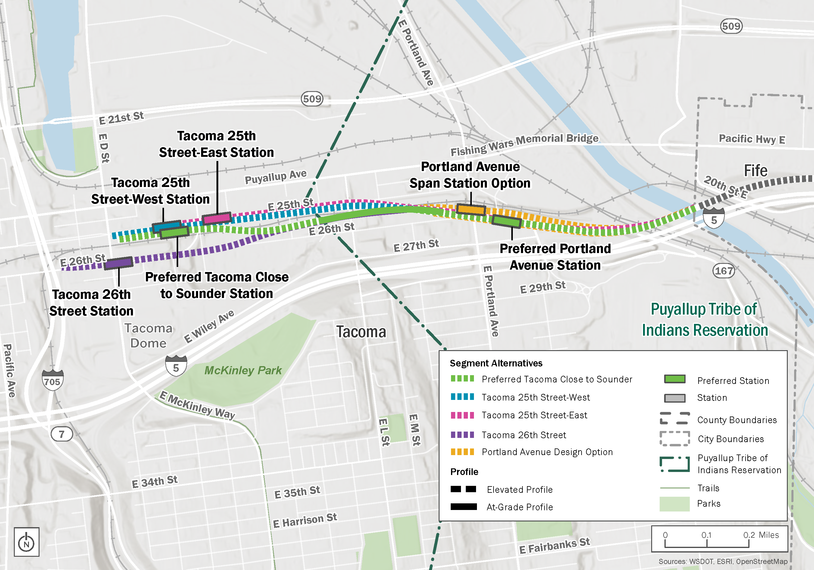
The Tacoma Segment includes the area from the Fife/Tacoma city limit across the Puyallup River to the existing Tacoma Dome Station, through reservation and trust lands of the Puyallup Tribe of Indians. The Portland Avenue Station area would be within the reservation lands. The Tacoma Segment of the project will have two stations: Portland Avenue and Tacoma Dome.
All of the alternatives would cross the Puyallup River north of I-5. Two bridge types are being studied for the crossing:
- A long-span bridge that would completely span the river.
- A pier-supported bridge that would have piers in the river.
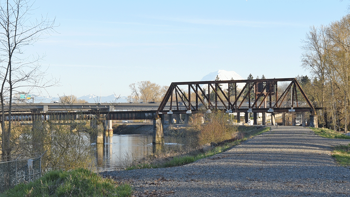
Existing view of the I-5 bridge deck
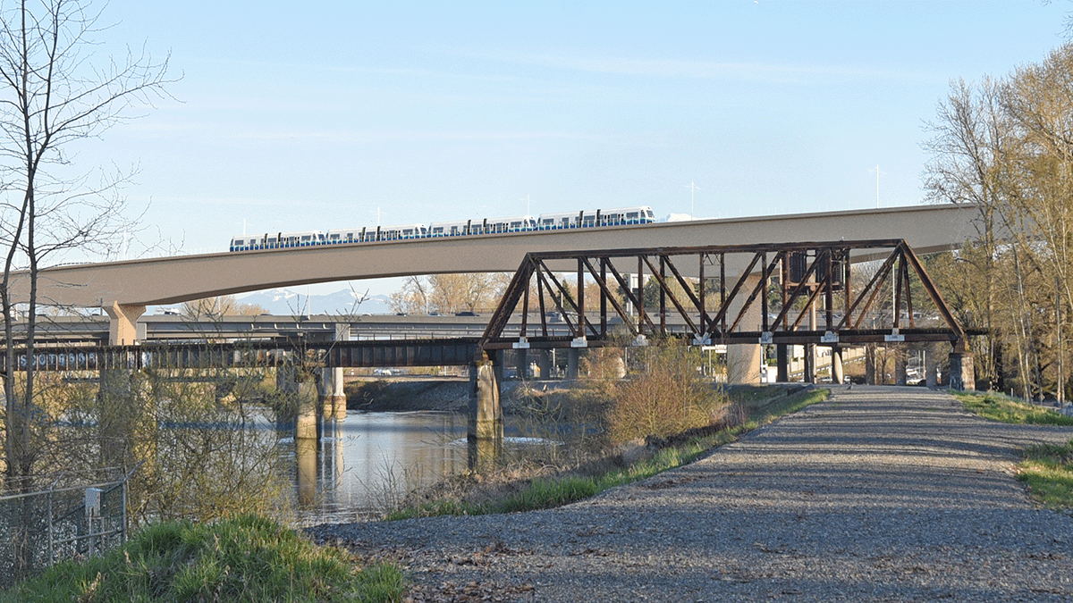
Long-span bridge visual simulation
The long-span bridge (segmental box girder) would be approximately 60 feet higher than the nearby I-5 bridge deck. The long-span bridge would be taller than the pier-supported bridge and could obstruct views of Mount Rainier, depending on the type of long-span bridge.
The long-span bridge would have fewer long-term impacts on aquatic habitats due to the lack of in-water structures.
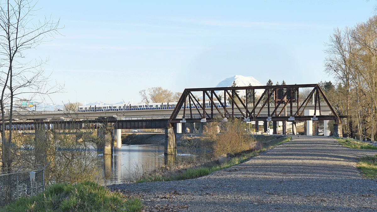
Pier-supported bridge visual simulation
The pier-supported bridge would be about 10 feet higher than the I-5 bridge deck and more aligned with the Washington State Department of Transportation (WSDOT) I-5 bridge, making the structure less prominent.
The pier-supported bridge would affect the flow of water, sediment, and other natural resources. Construction of the in-water piers may adversely affect fish and marine mammals, including endangered species.
Tacoma alternatives
In the Tacoma Segment, we studied four alternatives:
- Preferred Tacoma Close to Sounder Alternative
- Tacoma 25th Street-West Alternative
- Tacoma 25th Street-East Alternative
- Tacoma 26th Street Alternative
Each alternative could be paired with either of the Portland Avenue Stations.
Portland Avenue stations
After crossing the Puyallup River, all alternatives would travel northwest to serve the elevated Portland Avenue Station located between East Portland Avenue and East Bay Street.
We studied two station locations near Portland Avenue that could be paired with any of the alternatives:
- Preferred Portland Avenue Station
- Portland Avenue Span Station Option
Tacoma Dome stations
We studied four Tacoma Dome Station locations that each pair with one respective alternative:
- Preferred Tacoma Close to Sounder Station
- Tacoma 25th Street-West Station
- Tacoma 25th Street-East Station
- Tacoma 26th Street Station
Information for property owners
To build the TDLE project, Sound Transit will need to purchase and use private property. In some cases, this means relocating people from their homes or businesses.
If you are a property owner, you may have received a letter from Sound Transit about your property before the Draft EIS publication. This notification does not mean Sound Transit has decided that we need to purchase your property. Depending on the alternative selected to be built, Sound Transit may need to acquire some or all your property at a later project phase.
As a reminder, Sound Transit will not finalize decisions on affected properties and acquisitions until after publishing the Final EIS and Board action to select the project to be built. The Board action is expected in 2027.
Learn more now
Our project team is available to help with any questions you may have about this process. To learn more:
- Review our property acquisition and relocation handbooks
- Email tdlink@soundtransit.org
- Call 206-398-5453
Please note that specific effects to individual properties are not yet finalized. We know this period of uncertainty can be stressful. We are here to help.
Frequently Asked Questions
We notified potentially affected property owners before releasing the Draft EIS in December 2024. Being a potentially affected property owner means that your property is close to one or more alternatives we are currently studying. This notification of potential impact does not mean we are purchasing your property. Sound Transit will not finalize decisions on affected properties and acquisitions until after publishing the Final EIS and Board action to select the project to be built. The final Board action is expected in 2027. Sound Transit will notify and engage with affected property owners about property acquisition and relocation after the final Board action and issuance of the Record of Decision by the Federal Transit Administration.
Notification that your property is potentially affected does not mean we are purchasing your property. Instead, it suggests that, depending on decisions made in the future on the project that will be built, Sound Transit may need to acquire all or a portion of your property at a later project phase. We’ll update our list of potentially affected properties as we refine the project’s design. We won’t decide which properties to purchase until after a Final EIS and the Sound Transit Board selects the projects to be built.
Residential relocation
For residential property owners and tenants, Sound Transit provides three primary types of relocation assistance: advisory assistance, moving expenses, and replacement housing payments. A qualified relocation specialist will work with displaced residents to determine needs, explain benefits, help and advise with filing claims, and provide referrals to current housing inventories.
Business relocation
Sound Transit provides three primary types of relocation assistance: advisory assistance, moving expenses, and business re-establishment expenses. The level of benefits and advisory services differs for each displaced business depending on the complexity of the business operation.
Next steps
We will continue environmental review and coordination with key stakeholders until the publication of the Final EIS, expected in 2027. We will evaluate the Preferred Alternative along with other alternatives in the Final EIS.
2025–2026
- Environmental review and early design continue
2027
- Final EIS publication
- Sound Transit Board selects the project to be built
- Federal Transit Administration issues Record of Decision
Late 2027
- Begin final design
2029
- Begin construction
2035*
- Forecasted in-service date
* Parking at the South Federal Way and Fife stations is forecasted to open in 2038.

