
Project overview
Expanding regional light rail from Federal Way to Tacoma
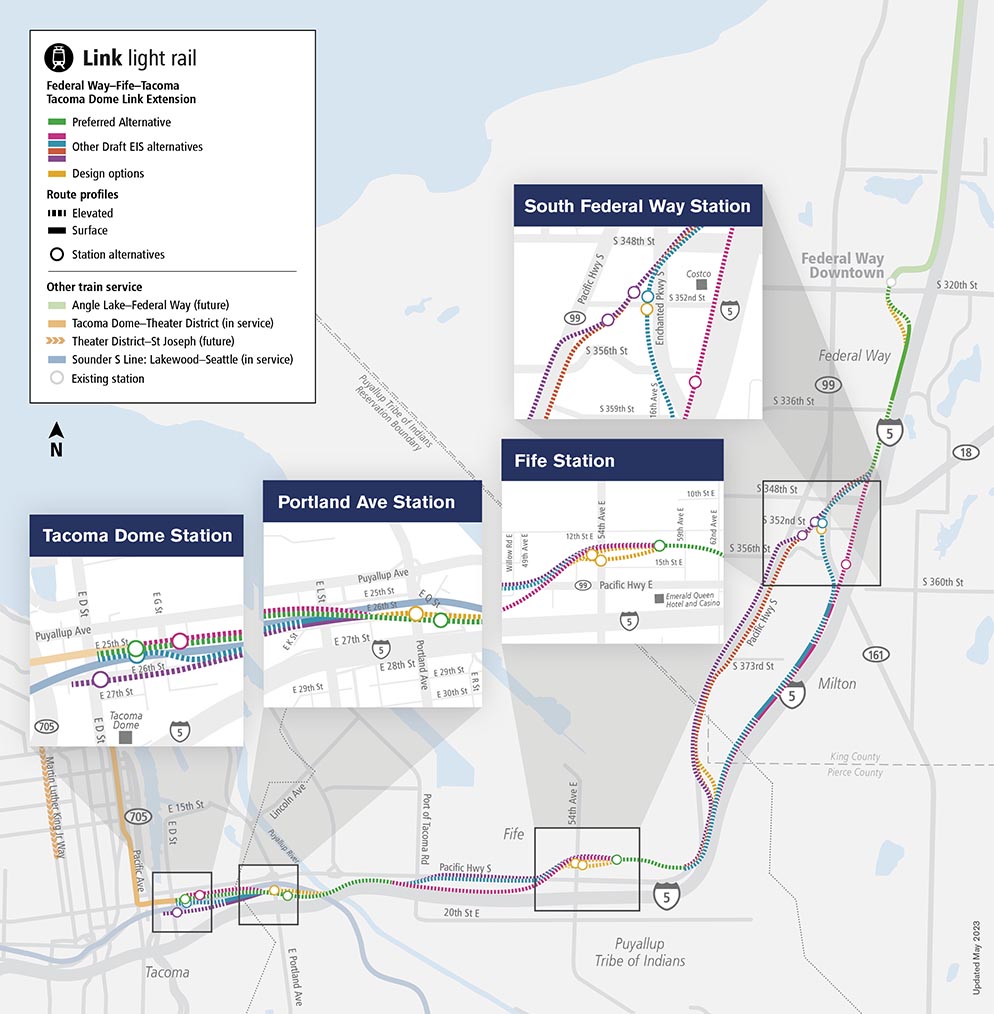
The Tacoma Dome Link Extension will add nearly 10 miles to our regional light rail system, via mostly elevated tracks between Federal Way and Tacoma. This project includes four new light rail stations in the South Federal Way, Fife, East Tacoma/Portland Avenue and Tacoma Dome areas. These stations will also provide connections to other regional transit services like the Sounder S Line, the Link T Line, ST Express, King County Metro, Pierce Transit, Intercity Transit and Amtrak.
The text below describes the image above
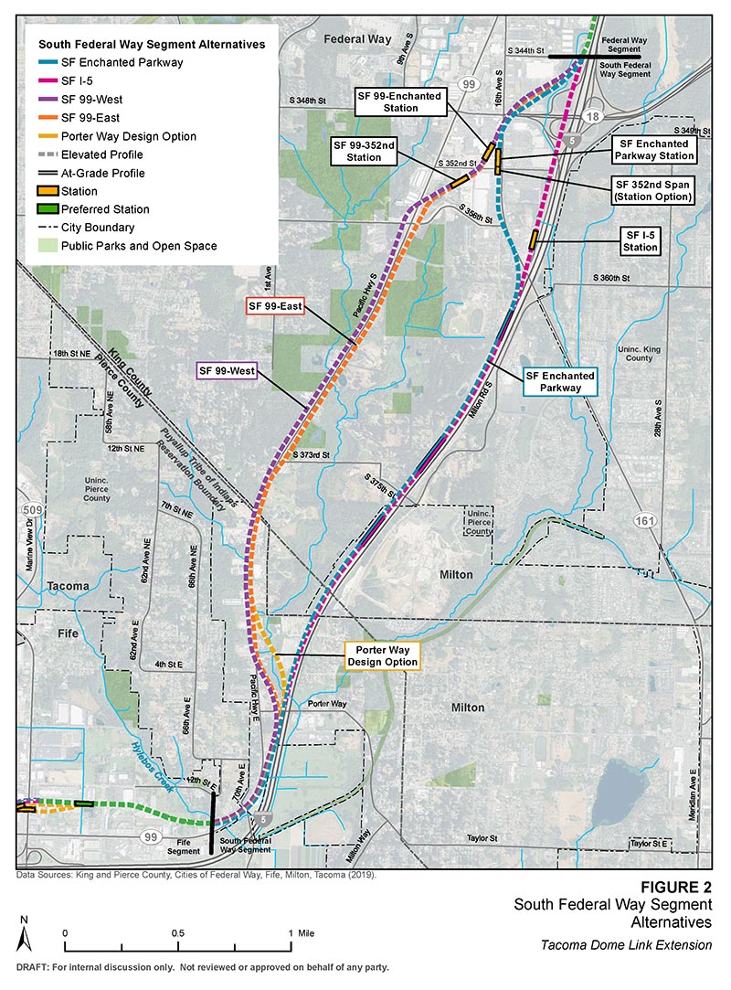
Map showing the Tacoma Dome Link Extension project. The project starts at the Federal Way Transit Center with a route traveling south with a station area in South Federal Way in the vicinity of Federal Way Crossings shopping center. The route continues south and curves west to enter a station area in Fife. The route continues west to cross over the Puyallup River to enter two station areas, one near Portland Avenue and one near the Tacoma Dome, where the project ends.
TDLE is currently in the planning phase. The routes and stations we are studying are called "alternatives." In most of the corridor, the Sound Transit Board identified a "preferred alternative,” which indicates a preference, and other alternatives to study in the Draft EIS.
EIS 101
Learn more about the upcoming EIS process
An Environmental Impact Statement, or EIS for short, provides Tribal Nations, agencies and the public an understanding of a project's potential impacts to the natural and built environment, and it identifies ways to mitigate unavoidable impacts. Through this process, we analyze each alternative and design option, considering things like effects on historic and cultural resources, residential properties, businesses, communities, the local economy and other resources.
The project is now in environmental review. We expect to publish the Draft EIS in mid-2024. At that time, we'll invite Tribal Nations, agencies and the public to provide formal comments. After consideration of the Draft EIS and comments received, the Sound Transit Board will confirm or modify the preferred alternative for further study in the Final EIS, along with the other Draft EIS alternatives.
Next, we'll prepare a Final EIS, including updates as needed. The Final EIS will also include responses to substantive public, agency and Tribal comments submitted on the Draft EIS.
After the Final EIS is published, the Sound Transit Board will select the project to be built.
To learn more about the different types of fieldwork activities we may conduct in your neighborhood, check out our fact sheet .
For property owners
Properties potentially affected by the additional route alternative and station option will be identified in the Draft EIS. We will notify potentially affected property owners before publication of the Draft EIS. Before then, contact us to request a briefing on the project or to learn more about Sound Transit’s property acquisition and relocation process. You can check out our TDLE project website, for more background on the project. We also recommend you sign up for project alerts so we can notify you directly whenever new information becomes available.
Federal Way
Federal Way
We're studying the following alternatives in the Federal Way Segment
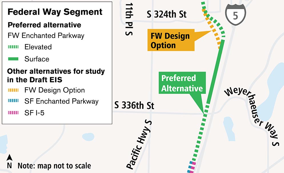
Routes
- Preferred FW Enchanted
- Parkway FW Design Option
Note: SF Enchanted Parkway and SF I-5 are included in the South Federal Way segment.
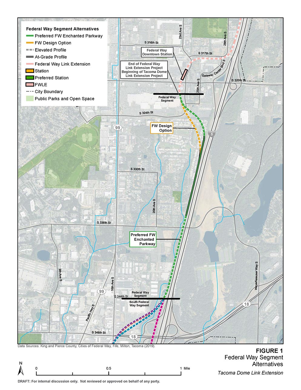
South Federal Way
We're studying the following alternatives in the South Federal Way Segment
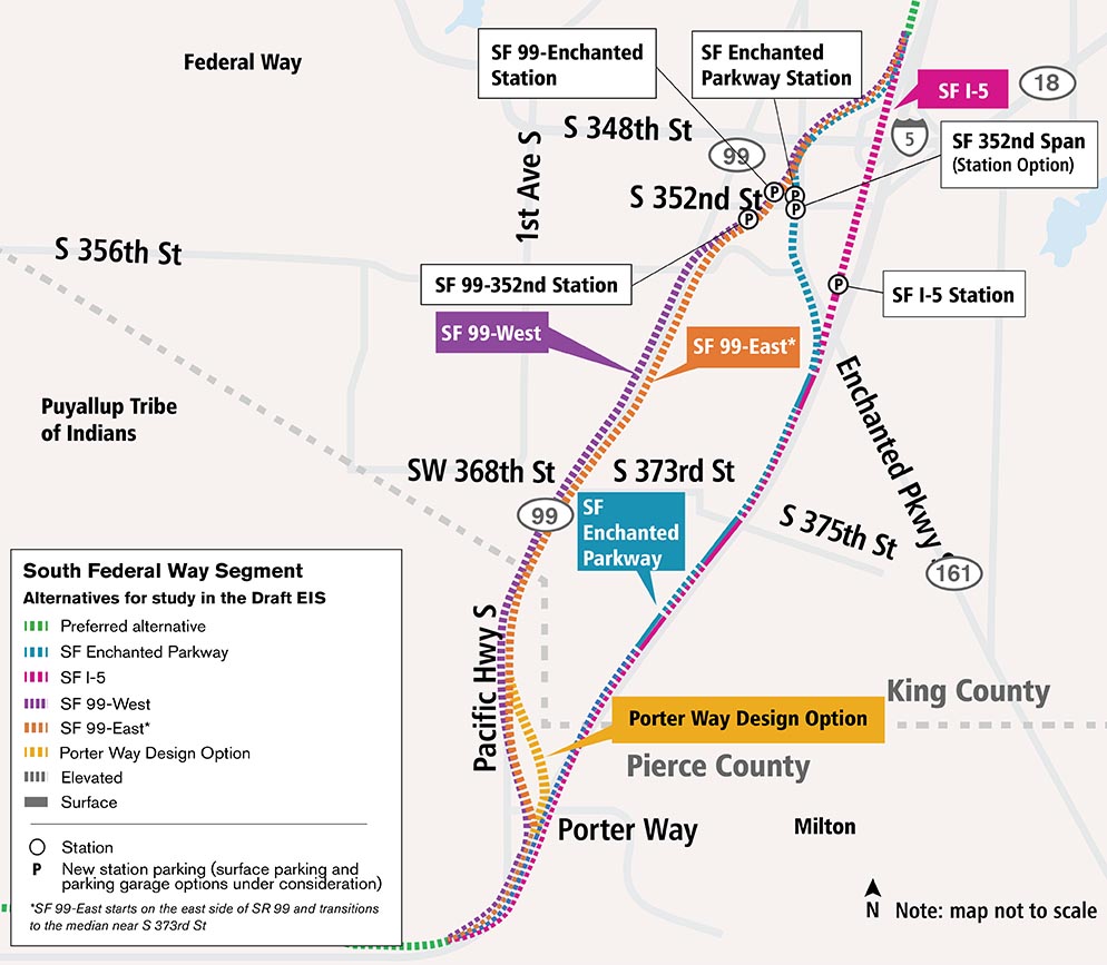
Routes
- SF Enchanted Parkway
- SF I-5
- SF 99-West
- SF 99-East
- SF Porter Way Design Option
Stations
- SF Enchanted Parkway Station
- SF 352nd Span Station Option
- SF I-5 Station
- SF 99-Enchanted Station
- SF 99-352nd Station
Latest updates (March 2023)
The Sound Transit Board updated the designation of SF Enchanted Parkway generally from the SF Enchanted Parkway station to the south from “preferred alternative” to “other alternative for study in the Draft EIS.” The alignment north of the SF Enchanted Parkway station will remain identified as the preferred alternative (Preferred FW Enchanted Parkway). A preferred alternative from the station area to the south will be identified after the publication of the Draft EIS. We will continue to study SF Enchanted Parkway, SF I-5, and the additional alternatives, SF 99-West and SF 99-East, in the Draft and Final EIS.
When we shared the potential Pacific Highway route on our maps in early 2023, we mentioned that the potential route from Federal Way to Milton represented multiple potential alternatives, including on both sides of Pacific Highway and in the median. You’ll now see SF 99-West and SF 99-East alternatives on maps and for study in the Draft EIS, which is anticipated to be published in mid-2024. SF 99-East starts on the east side of Pacific Highway then transitions into the median near South 373rd Street. Studying both routes provides us flexibility to analyze mitigation of various potential impacts through this corridor.
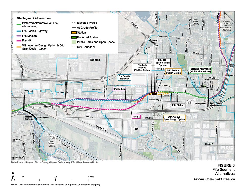
Fife
We’re studying the following alternatives in the Fife Segment
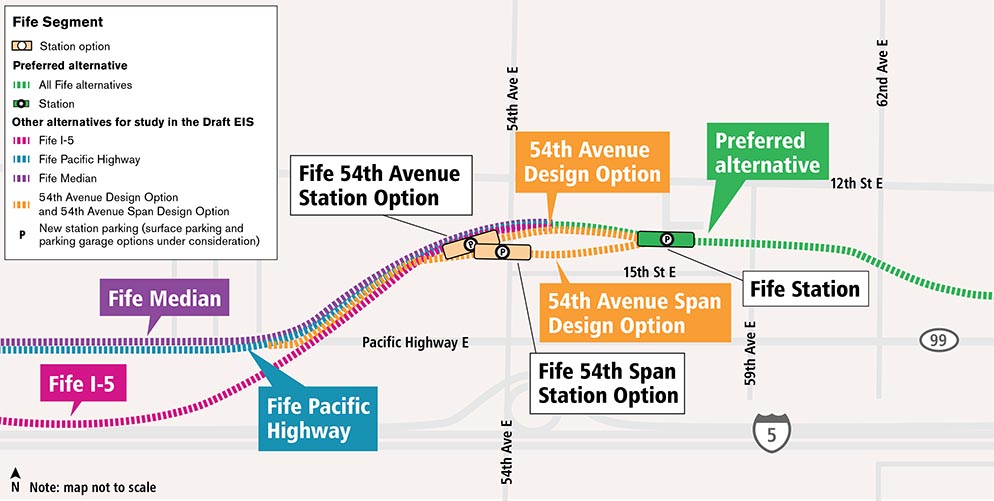
The text below describes the image above
After leaving Federal Way, the Sound Transit Board’s Preferred Alternative route, Preferred Fife alternative, follows I-5 until it begins to gradually curve at Porter Way to briefly align and then cross over SR 99, also called Pacific Highway East. The route then curves northwest until it runs east-west, just south of 12th Street East. The route then enters the elevated Fife Station on the west side of 59th Avenue East, which is part of the preferred alternative. Federal regulations and guidance for floodplain management require us to consider alternatives found outside of the floodplain. We’re now proposing to study two more potential station options—the Fife 54th Span Station Option and Fife 54th-West Station Option—outside of the designated floodplain. For the routes we are studying in Fife and from the Preferred Fife alternative, one route would curve slightly north toward 12th Street East and cross over 54th Avenue East to enter Fife 54th-West Station with a southwest slanted orientation. Second, from the Preferred Fife alternative, the other route curves slightly south toward 15th Street East to enter Fife 54th Span Station, which spans 54th Avenue East just north of 15th Street East. After exiting the station, we are studying three route alternatives that travel west. The Fife Pacific Highway elevated route exits the station westward and crosses over 54th Avenue East before crossing and transitioning to the south side of Pacific Highway near Willow Road. This elevated route continues along the south side of Pacific Highway until it reaches 34th Avenue East where it transitions south to the north side of I-5 on its way to the Tacoma segment of the project. We are also studying a route called Fife Median. This route is similar to the Fife Pacific Highway route; however, it is elevated in the median of Pacific Highway until it reaches 34th Avenue East where it transitions south to the north side of I-5 on its way to the Tacoma segment of the project. Lastly, we are studying the Fife I-5 route. This route exits Fife Station westward and crosses over 54th Avenue East and veers south, crossing over Pacific Highway to gradually curve to align with the north side of I-5 on its way to the Tacoma segment of the project. All of these routes alternatives converge back to the preferred alternative route that crosses the Puyallup River en route to Tacoma.
Routes
- Preferred alternative (all Fife alternatives)
- Fife Pacific Highway
- Fife Median
- Fife I-5
- Fife 54th Avenue Design Option & Fife 54th Span Design Option
Stations
- Fife Station (Preferred)
- Fife 54th Avenue Station Option
- Fife 54th Span Station Option
Portland Avenue
Explore what we’re studying in the Portland Avenue station area of the Tacoma segment
The Tacoma Segment of the project will have two stations: at Portland Avenue and the Tacoma Dome. We’re studying the following alternatives in the Portland Avenue area:
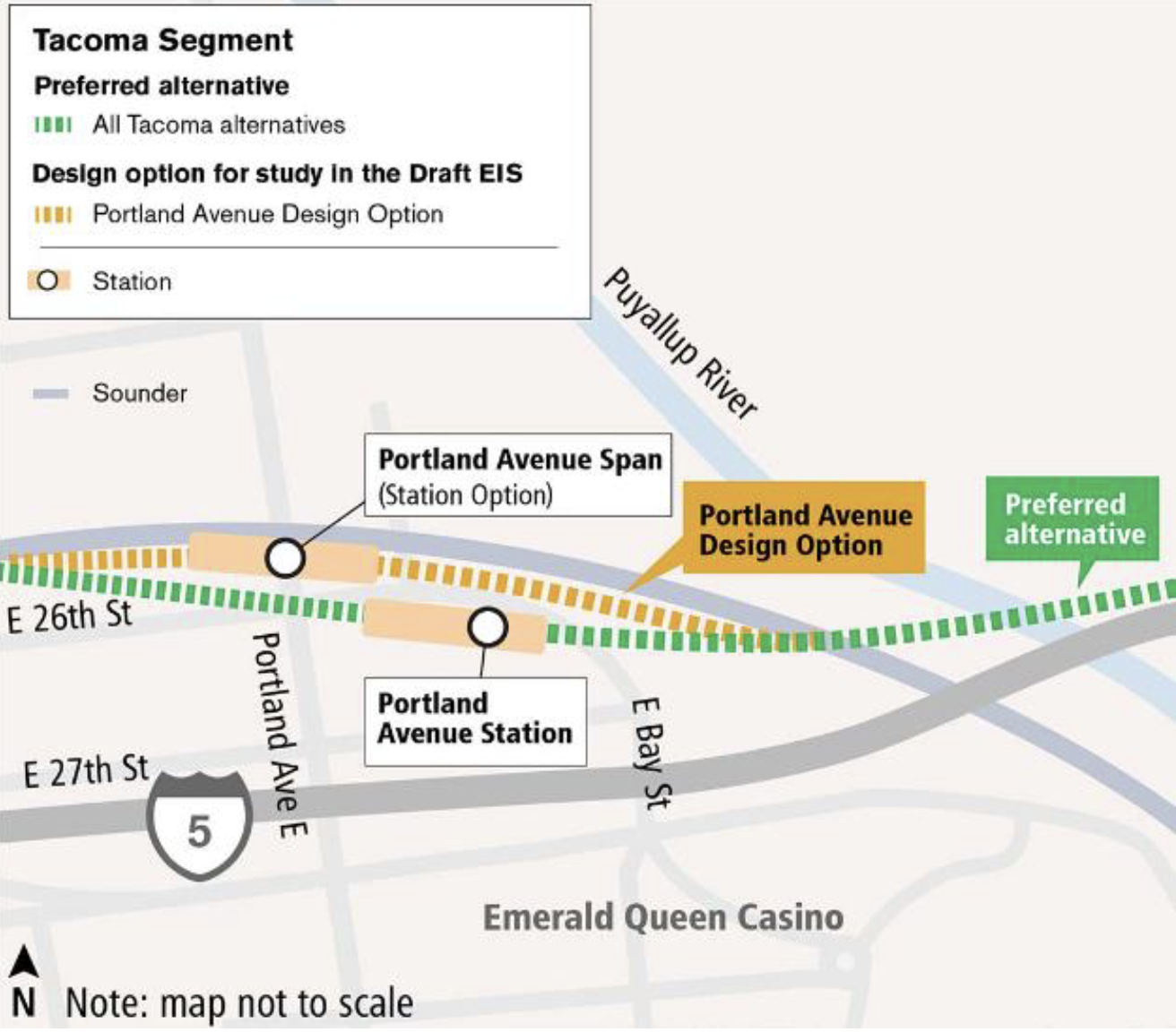
Routes
- (Preferred) All Tacoma alternatives (Tacoma 25th Street-West)
- Portland Avenue Design Option
Stations
- Portland Avenue Station
- Portland Avenue Span Station Option
We will update our early conceptual designs as the project progresses.
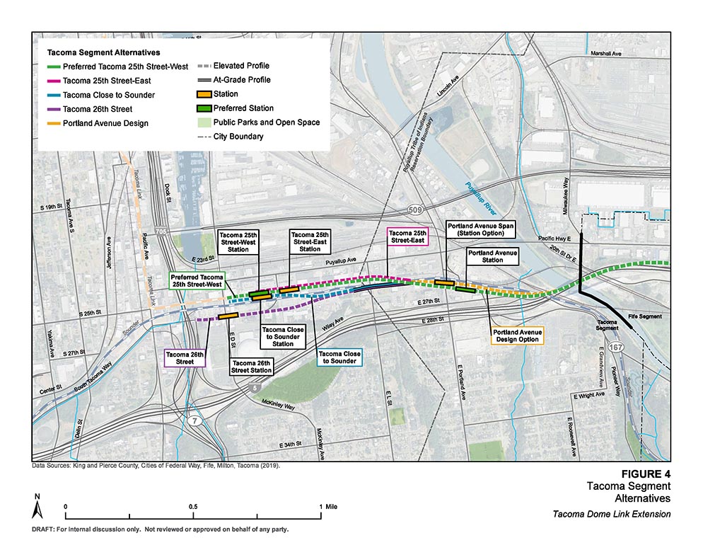
Tacoma Dome
Tacoma Dome
Explore what we’re studying in the Tacoma Dome station area in the Tacoma segment
The Tacoma Segment of the project will have two stations: at Portland Avenue and the Tacoma Dome. We’re studying the following alternatives in the Tacoma Dome area:

Routes
- (Preferred) Tacoma 25th Street-West
- Tacoma Close to Sounder
- Tacoma 25th Street-East
- Tacoma 26th Street
Stations
- Tacoma 25th Street-West Station
- Tacoma Close to Sounder Station
- Tacoma 25th Street-East Station
- Tacoma 26th Street Station
Tacoma Dome Access Improvements Project
Overview
The Tacoma Dome Access Improvements (TDAI) is an ST2 project that was approved by voters in 2008 and dedicates funding to improve how we get to the Tacoma Dome Station area. This will be accomplished through a surface parking lot with up to 300 stalls*, and/or a flexible approach to improve rider access through pedestrian, bicycle, or other transit-related improvements.
Sound Transit, in coordination with the City of Tacoma, and through previous public engagement, has identified a list of potential access improvements including new surface parking options and a variety of pedestrian, bicycle, and ADA enhancements near the Tacoma Dome Station. We invite your comments on these potential projects.
*Parking at Tacoma Dome Station (P)
There are 2,300 parking spaces in two adjacent garages that provide access for drivers to the station area. Additionally, there is on-street parking and nearby private lots that offer paid daily and monthly parking.
When voters approved funding for TDAI in 2008, parking demand exceeded capacity, but since 2020, parking capacity has exceeded demand. Today, the garages are typically about 50% full each weekday.
A closer look at access improvement options
Surface Parking Background
Sound Transit performed a study of potential surface parking sites near the Tacoma Dome Station area for TDAI. We reviewed new parking options as well as possible leased parking options in our assessment. We learned leasing parking from existing sites is more expensive for Sound Transit over the long-run and creates no net new parking for Sound Transit riders, so Sound Transit opted to focus on potential new parking sites instead. New surface parking in the Dome District is limited to areas not adjacent to pedestrian streets per City of Tacoma policy, which combined with the project evaluation criteria, informed the potential TDAI parking location
Bicycle and Pedestrian Projects Background
Sound Transit used previous public engagement input and collaboration with the City of Tacoma to develop the list of bicycle, pedestrian, and safety improvements for the potential TDAI projects. We derived these projects from the TDLE Station Access Allowance project list which was created in 2020 during early Tacoma Dome Station planning. We then filtered the larger list through the evaluation criteria to provide the 11 potential TDAI projects you see on the map.
Evaluation criteria
Sound Transit and the City of Tacoma evaluated potential access improvements with these criteria:
- Growing transit ridership.
- Improving connectivity between transit modes.
- Improving safety and human health.
- Enhancing passenger experience.
- Advancing social equity.
Sound Transit is also using additional criteria to evaluate the TDAI projects including:
- Proximity to Tacoma Dome station area.
- Alignment with City of Tacoma projects.
- Potential for future TDLE construction impacts.
The TDAI project descriptions section below includes a score (high, medium, or low) for the performance of each access improvement project based on these criteria. Read our methodology document for more information about the evaluation criteria.
Potential TDAI Projects
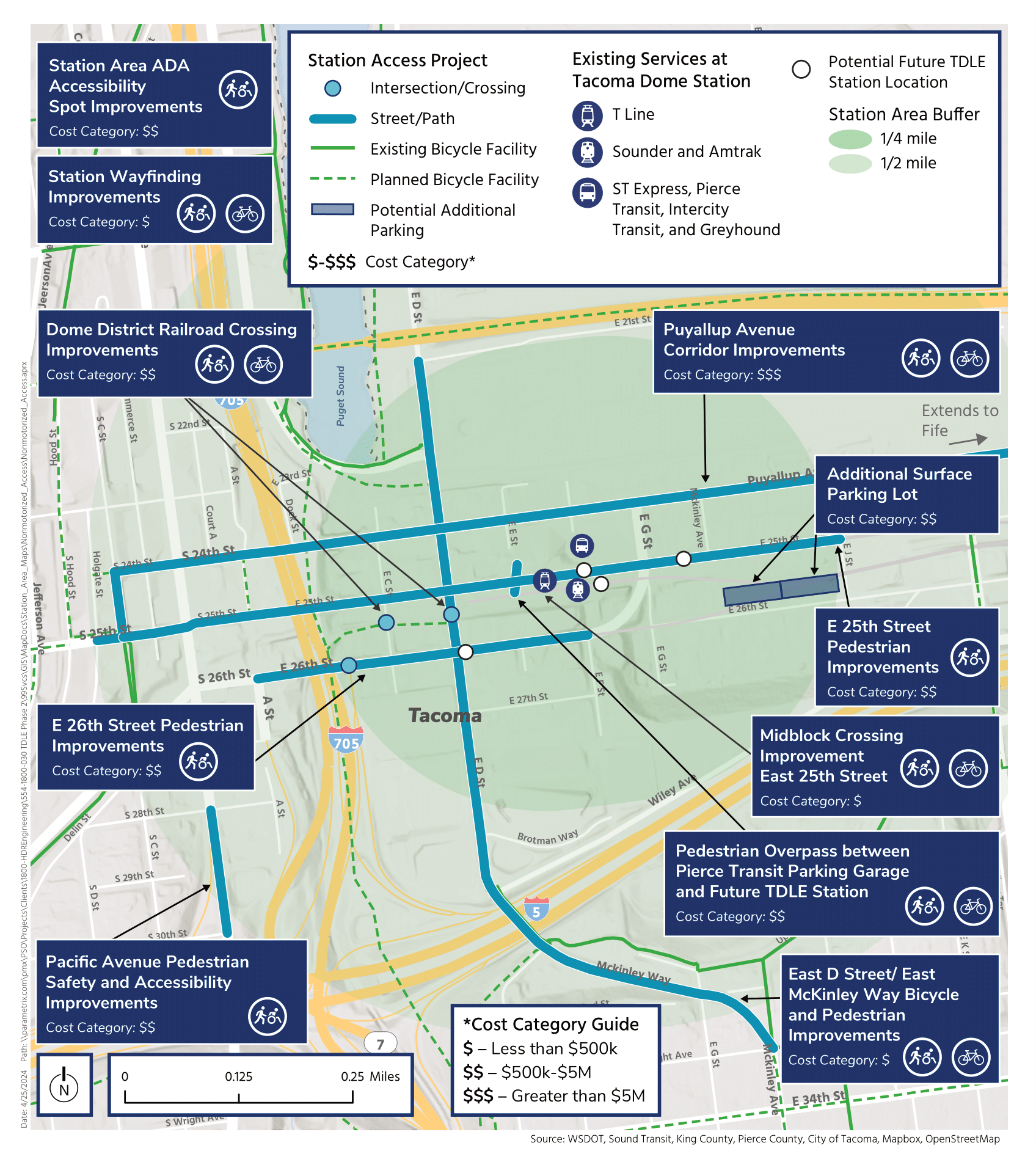
*Cost category guide
$ – Less than $500k
$$ – $500k - $5M
$$$ – Greater than $5M
These estimates represent construction costs based on preliminary stages of design and are subject to change.
How should we prioritize the access improvements?
Take our survey!
Next steps for TDAI
Sound Transit and the City of Tacoma will consider community feedback to further refine the list of potential improvements and provide an update to the Sound Transit Board. We will then complete an environmental review of the proposed improvements and re-engage the community. The Sound Transit Board will confirm or modify the set of improvements to be built in 2025. Following this decision, the TDAI projects will continue into the design phase, and additional refinements to the projects will be shared with the public. In partnership with the City of Tacoma, we expect to complete the TDAI projects in 2032. Subscribe to receive ongoing updates about our TDAI work with the City of Tacoma.